


Hurricane Erin threatened the East Coast with dangerous rip currents as the large storm was expected to grow while moving on a projected path up the Atlantic Ocean, the National Hurricane Center in Miami said Tuesday. The hurricane isn’t expected to make landfall in the U.S., but people in North Carolina’s Outer Banks were warned of possible coastal flooding that triggered evacuation orders.
Erin, the first Atlantic hurricane of 2025, was downgraded to a Category 2 storm Tuesday morning as it churned over the Atlantic Ocean north of the Caribbean. It previously exploded to a Category 5 on Saturday before weakening to a Category 3 early Sunday morning, then regaining strength again later in the day.
As of 2 p.m. EDT Tuesday, Erin had maximum sustained winds of 105 mph and was moving north-northwest at 10 mph. The storm’s center was about 630 miles southwest of Bermuda and about 655 miles south-southeast of Cape Hatteras, North Carolina.
A Category 2 hurricane is defined as having maximum sustained winds from 96 mph to 110 mph. Erin was just under what’s considered a major storm, capable of causing devastating damage with maximum sustained winds of at least 111 mph. Forecasters said fluctuations in Erin’s strength were possible over the next few days.
NOAA/NESDIS/STAR GOES-19 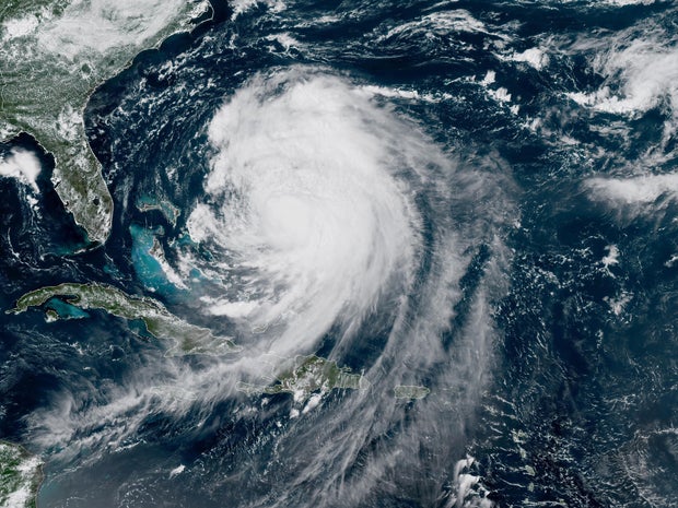
Maps show Hurricane Erin’s forecast path
The center of the storm was expected to turn to the north-northwest on Tuesday, passing to the east of the Bahamas, and move between Bermuda and the U.S. East Coast Wednesday and Thursday, the hurricane center said.
CBS News 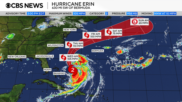
Erin is already a large storm, with hurricane-force winds extending outward up to 80 miles from the center and tropical storm-force winds extending up to 230 miles from the center, forecasters said.
Tropical storm warnings were in effect for the string of barrier islands along the North Carolina coast known as the Outer Banks, the hurricane center said. A tropical storm watch was issued north of the Outer Banks to southern Virginia. A tropical storm warning means tropical storm conditions are expected somewhere within the warning area, while a watch means they are possible.
CBS News 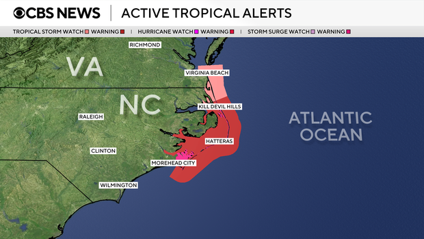
A storm surge warning was also issued for the Outer Banks, meaning there was a danger of life-threatening inundation from coastal flooding that was expected to start Wednesday.
Hurricane Erin’s “spaghetti models”
A “spaghetti map” of the forecast models shows the storm skirting the Caribbean islands and remaining well offshore of the U.S. East Coast as it moves north and curves back over the Atlantic.
CBS News 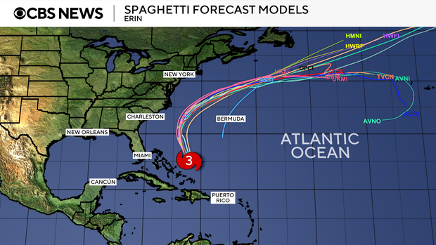
A high-pressure system in the Atlantic was expected to steer Erin away from the U.S. coast while a cold front was also forecast to push the hurricane offshore, CBS News Bay Area meteorologist Jessica Burch reported.
When is Hurricane Erin expected to impact the U.S.?
Erin isn’t forecast to hit the U.S. directly, but the initial effects of the storm were expected to be seen as early as Tuesday afternoon’s high tide cycle along the North Carolina coast, according to the National Weather Service office for Newport/Morehead City. The time for high tide varies across the Outer Banks, from 5:14 p.m. EDT for Jennette’s Pier in Nags Head to 6:32 p.m. at U.S. Coast Guard Station Hatteras.
The worst conditions were expected late Wednesday through Thursday, when the center of Erin was expected to be at its closest point to the coast, according to the weather service. Along the Outer Banks, the weather service warned of the potential for severe flooding to reach buildings and roads. Many roadways will likely be under several feet of water and inaccessible for several days due to the flooding.
Mandatory evacuations were ordered for Hatteras Island and Ocracoke Island in the Outer Banks ahead of the expected flooding.
Coastal areas along the Eastern Seaboard will feel the effects of Erin with dangerous rip currents and high waves of 10 to over 20 feet over the next several days.
CBS News 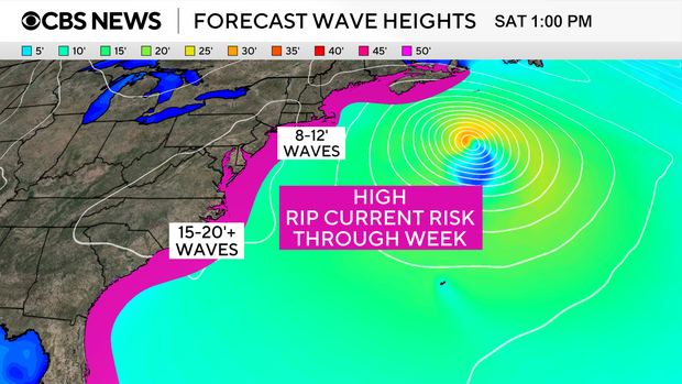
Mike Brennan, the hurricane center’s director, said the dangerous conditions were expected to last for much of the week across almost the entire East Coast. He urged people to heed any warnings from local officials.
“It’s just not going to be a very safe environment to be in the ocean,” Brennan said.
Rip currents a potentially deadly threat
Rip currents are narrow channels of fast-moving water that commonly occur along U.S. coastlines and can pull even strong swimmers away from shore. They’re the reason for more than 80% of beach rescues.
In addition to the warnings along the North Carolina coast, some beaches ranging from South Florida up to New England are also taking precautions.
Erin is expected to bring dangerous rip currents along the Jersey Shore and south-facing New York beaches on Tuesday, CBS News New York reported, with the risk continuing through the week. Officials at some New Jersey beaches and the popular summer destination of Rehoboth Beach, Delaware, have already prohibited swimming as a precaution, and more closures may follow.
“You’re allowed on the beach, but you will not be allowed in the water because we have treacherous conditions going on right now,” said Ed Schneider, beach patrol captain in Wildwood, New Jersey, told CBS News Philadelphia. “We have a rip current warning, we have [a] rough surf warning, we have [a] storm warning, and conditions are bad.”
First hurricane of the Atlantic season
Erin formed as a tropical storm last week west of the island nation of Cabo Verde, a few hundred miles off Africa’s western coast. It is the fifth named storm of the 2025 Atlantic hurricane season, which started in June and runs through November. Erin strengthened to a hurricane on Friday.
So far this year, Tropical Storm Chantal is the only one to have made landfall in the U.S., bringing deadly flooding to North Carolina in early July. In June, Barry made landfall as a tropical depression on Mexico’s eastern coast.
Erin’s increased strength comes as the Atlantic hurricane season approaches its peak in September. According to the hurricane center, most of the season’s activity typically happens between mid-August and mid-October. In the eastern Pacific Ocean, hurricane season starts on May 15 with a peak in activity typically seen in late August.
CBS News 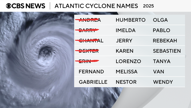
The U.S. National Oceanic and Atmospheric Administration, or NOAA, forecast an above-normal season for the Atlantic this year, expecting between 13 and 18 named storms.
Tropical storms have maximum sustained winds of at least 39 mph. Forecasters with NOAA anticipated that between five and nine of the storms this year could become hurricanes, which have sustained winds of at least 74 mph. Hurricanes are rated on a scale based on their wind speeds, ranging from Category 1, the weakest, to Category 5, the most severe rating.
NOAA forecasters predicted there could be between two and five major hurricanes in the Atlantic this season.
Nikki Nolan
contributed to this report.